
Achi news desk-
A large, slow-moving area of low pressure is bringing periods of a mix of snow and rain across the Maritimes on Thursday to start the weekend.
Slick roads develop Thursday
The first of the snow arrives in southwestern New Brunswick and southwestern Nova Scotia before sunrise on Thursday. Wet snow will then spread across New Brunswick and mainland Nova Scotia during the day. There will be a chance of flurries or showers for Prince Edward Island and Cape Breton. The snow may mix with rain for Nova Scotia and parts of southern New Brunswick.
Snow amounts of five to 15 cm are expected in southwestern New Brunswick and western Nova Scotia Thursday afternoon and evening. Accumulation may vary due to some of the snow melting as it reaches the ground and if any rain mixes in. Drivers should be careful of the accumulating snow and slushy which could make roads slick. Visibility can also be reduced in snow that falls for periods of time.
Watch for snow or slushy accumulations on roads during the day, especially in southwestern New Brunswick and western Nova Scotia. (Source: CTV News Atlantic)
High and gusty easterly winds are expected to develop for parts of the Maritimes on Thursday. Gusts could reach 50 to 70 km per hour for southern New Brunswick, Nova Scotia, and Prince Edward Island Thursday afternoon and evening. Exposed coastal areas on the southwest coast of New Brunswick and Nova Scotia could experience maximum wind gusts of 70-to-100 km/h.
More snow added Friday
Thursday night and Friday morning the heavier snow will move to eastern New Brunswick, eastern Nova Scotia, and western Prince Edward Island. That could lead to a snowy, slippery Friday in communities like Bathurst, Moncton, and Sydney, among others. There is a general five-to-15 cm of wet snow, but more for some areas.
Northeastern New Brunswick could see snow totals of 15-to-30 cm for the area from Miramichi north to Campbellton and east across the Acadian Peninsula. Thirty to 45 cm is possible in the upper elevations of Northumberland, Gloucester, and eastern Restigouche counties. The higher elevations of the Cape Breton Highlands could also receive snowfall approaching 30 cm.
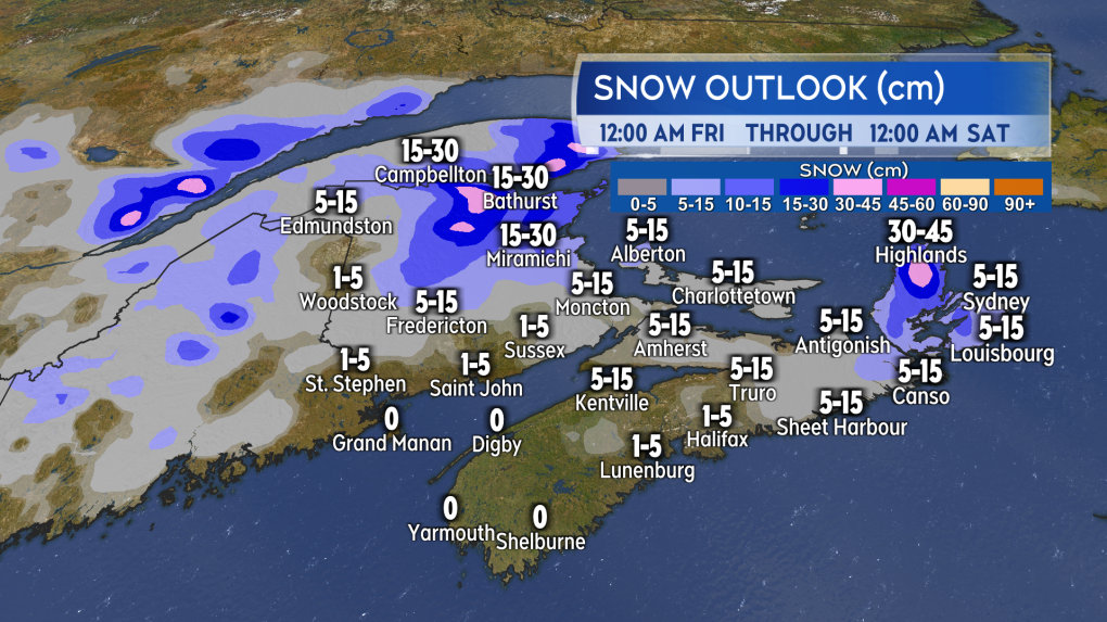 Heavier snow accumulation possible in northeastern New Brunswick and the Cape Breton Highlands on Friday. (Source: CTV News Atlantic)
Other areas of the Maritimes can expect a lighter mix of flurries and showers during the day. Wind will be out of the east and south-east on Friday with gusts of 30 to 60 km per hour.
Waiting for Saturday
As the center of the low stands east of the Maritimes, further periods of a sleet mix are possible Friday night and Saturday. Given the multi-day duration of the weather event, it is too early to assess how much additional snow could fall on Saturday. In most cases it looks like it will be lighter compared to the areas of more consistent snow expected on Thursday and Friday. There will be a northeasterly wind on Saturday with gusts of 20 to 50 km per hour.
On to Monday and the eclipse
If we’re looking for a silver lining in the forecast, here’s the forecast for Monday’s eclipse viewing. A weak ridge of high pressure is expected to be building from the west. That should keep clouds in the Maritimes patchy in coverage for Monday afternoon.
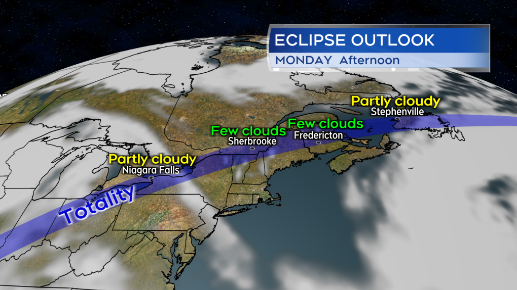 Fingers crossed, but the overall weather pattern looks favorable for Monday’s solar eclipse viewing in the Maritimes. (Source: CTV News Atlantic)
